Note: This is a massive download at 4.3 Gigabytes. Please only order if you have a fast and stable connection - or also order the DVD backup service.
MegaScenery Pacific Northwest puts you in the Flight Simulator skies above a massive expanse of the Pacific Northwest and lets you experience flight at a level of realism that you've previously only imagined.
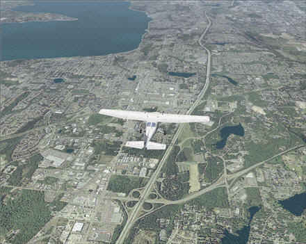
Soar the Flight Simulator Skies Above Seattle and 30,000 Square Miles (76,000 sq km) of Spectacular Surrounding Areas of The Pacific Northwest and Washington State. Four Scenery Technologies In One Give You A Total Of 90,000 Square Miles of Unique Scenery.
MegaCity Technology brings out the finest real-world detail in the city down to the level of you being able to see vehicles on highways and sandtraps on golf courses.
MegaScenery Pacific Northwest is the largest and most realistic photorealistic scenery ever produced for Microsoft Flight Simulator 2004 and it is, by far, our best MegaScenery title yet!
Created from digitized 5 meter per pixel satellite and 1 foot per pixel aerial photographs this product enables you to experience - for yourself - flight above some of the most visually spectacular terrain in the USA – the Pacific Northwest, Seattle and surrounding areas.
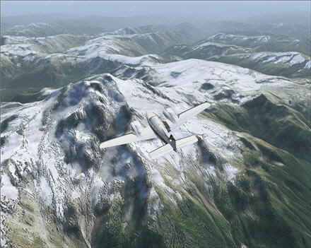
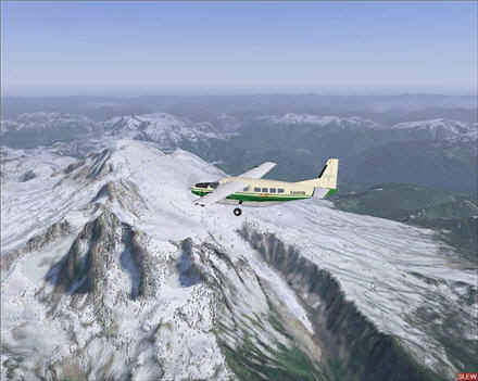
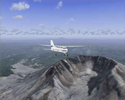
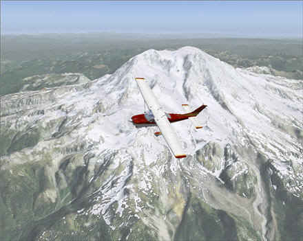
MegaScenery Pacific Northwest captures all of the landmarks in the area just as you see them in real life. Now... you can experience the rush of flying within feet of the real Mt Rainier with its 14,000 feet peaks. Recently, Mt St Helens was going to erupt again… well now you can fly into her crater and explore the remnant spills of when she did erupt in 1980. The Olympic Mountains, Mt Adams, Puget Sound and more… they’re all as real as life and are just a few features the area is famous for.
And then… to top off the realism MegaScenery puts you over the top of The Emerald City – Seattle using our new MegaCity Technology. It’s city scenery developed from high resolution (1 foot per pixel) aerial photography and will have you spotting even the finest details down to individual rooftops and even shrubs and sandtraps on golf courses and vehicles on interstates.
4 SCENERY PRODUCTS IN ONE GIVE YOU A TOTAL OF 90,000 Square Miles Of Unique Scenery!
You don't just get day scenery.... you get 4 scenery products in one in this incredibly value-packed scenery title. No other scenery product has ever given you so much value for your money.
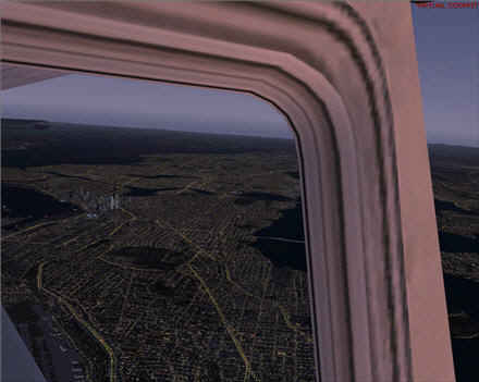
1. Photorealistic DAY Scenery - Actual satellite photographs (5 meters per pixel) ported into Flight Simulator 2004 for a scenery world that looks just like the Pacific Northwest area from a pilot's vantage point. You are flying over THE actual Pacific Northwest.2. Spine Tingling NIGHT Scenery - MegaScenery's UNIQUE proprietary Night Scenery mapping technology recreates the entire scenery area again at night. No... it's not just random lights - MegaScenery knows where every light emitting source in the area covered is right down to the street level. No other product gives you such a realistic night flying experience. The only way to describe the effect is "spine-tingling". When you're flying over Seattle - or remote mountainous regions for that matter - it looks just like it would at night in real life as streets, subdivisions and even interstates light up. You get to truly experience flying Night VFR!3. WINTER Scenery - Another UNIQUE and proprietary scenery creation technology - MegaScenery's advanced processes use the original satellite images to recreate just what that world would look like after a snowfall. No... it's not just a white blanket.... again a series of advanced algorithms comb through the images and distinguish every scenery element and applies our "snow effect" to recreate another 30,000 unique square miles of the Pacific Northwest after a snowfall. This occurs when you are flying in Winter.4. NEW MegaCity Technology - 5 meter satellite imagery is more than you'll ever need for a realistic cross country experience. When it comes to cities, a little more resolution is required to bring out the fine detail of streets, subdivisions, golf courses and the like. The entire urban area of Seattle has been recreated from 1 foot per pixel aerial photos. You will, if you live in the area, be able to clearly identify your own street and even spot your own house!
ENJOY HUNDREDS OF HOURS OF FLYING
-
30,000 square miles (175 nm x 175 nm - with the longest points 250 nm apart) of photorealistic day scenery
-
30,000 square miles (175 nm x 175 nm - with the longest points 250 nm apart) of photorealistic night scenery
-
30,000 square miles (175 nm x 175 nm - with the longest points 250 nm apart) of photorealistic winter scenery.
A total of 90,000 square miles of unique scenery lets you explore this most visually spectacular area of the United States. This is a LOT of area and will take you months to explore in full - many hundreds of hours of flying over terrain where every square foot of the world moving beneath you is unique and REAL and NOT just repeating default textures. Day, Night and Winter!
MegaScenery Pacific Northwest is the best MegaScenery 2005 yet and yes, you will pinch yourself for a reality check.
PLUS ALL THE PDF CHARTS YOU NEED TO NAVIGATE YOUR WORLDWith MegaScenery Pacific Northwest, you're flying over the real world! We believe there's no sense in flying blind. So we've given you all of the actual, full size and proper scale, copies of FAA aeronautical maps and charts required to navigate every square mile of your scenery. You get a complete VFR (and IFR) flying kit when you order the "Full Kit" version. You get the following PDF full color FAA maps with your scenery:
-
1 Double Sided Full Color Seattle Sectional Aeronautical Chart
-
1 Double Sided Full Color Seattle Terminal Area Chart & VFR Flyway Planning Chart
-
220 instrument approach charts.
-
ALL CHARTS ARE IN PDF FORMAT
MEGASCENERY USA 2005: Volume 4 - PACIFIC NORTHWEST IS THE BEST MEGASCENERY TITLE YET AND INCLUDES ALL THE LATEST MEGASCENERY TECHNOLOGY DEVELOPMENTS:
-
New MegaCity™ Technology
-
Flying in all 4 seasons
-
Improved Night Scenery
-
Winter Snow Scenery.
-
High resolution 30 meter terrain elevation mesh. Mountains have never looked so real!
-
Repositioning of incorrectly placed default FS2004 objects
-
Many other tweaks and fine enhancements
Say Goodbye To Default Flight Simulator Scenery Forever - Your Flight Simulator world will NEVER look the same again!
Stop for a moment to imagine the scenery world you’ve always dreamed of flying with Microsoft Flight Simulator…. MegaScenery Pacific Northwest is that scenery!
This title will install with Flight Simulator X using the automatic installer available from http://www.megascenery.com/megafsx.htm
|