FSMap is an application that brings paper charts into the digital age. It consists of two parts that can be used separate or together; the main FSMap program and the FSMap gauge that will be part of your aircraft panel.
FSMap
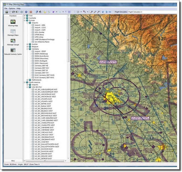
The main application is both the 'map manager' and a stand-alone Moving Map that can run on the same system or on a separate computer.
Moving Map mode - When connected to FS (FS2002/FS2004 and FSX are supported) the moving map function of FSMap will show your position on the digital maps in your collection. The moment you get into a location that is covered by another map it will be loaded automatically, for example when you get close to an airport it could load that airport approach chart and when you get close to an ILS it could load the ILS approach chart for that runway, all automatically. All map manipulations are done using very fast routines so even large charts rotate, zoom and move fluently and you can choose from many different view options (north up/track up etc).When not connected to FS it is still a very powerful map viewer with superb manipulation tools and some fine options. For example it can show all traffic and controllers for the online flying community. So you can see where the action is before going online and even at what gate you friend is all the data is presented on top of your own charts in real time.
Manage Map mode - In this mode you can add, remove and edit maps. Any kind of bitmap file can be imported, from ocean route maps to highly detailed taxi charts and as long as you know the lat/lon of two points on the chart you can calibrate it so it can be used by FSMap. All maps are stored and managed in regions so even if you have hundreds of maps in the system it\'s is easy to find the map you need.
Manage Gauge & Rebuild Navigation Database mode - In these utility modes you can add the FSMap gauge to aircraft panels in a most comfortable way. Using simple drag and drop options you add the gauge to an aircraft panel, assign click zones and even hot keys. Real easy, real fast. As soon as you add new scenery files you can rebuild the database. It will extract al information about airports, runways, navaids from FS so it can be used by the systems.
The Gauge
Installed as part of an aircraft panel this gauge that is based on the well known Garmin GMX 200. This multifunction instrument combines a Moving Map with a Traffic Collision Alert System and the novel SafeTaxi feature.
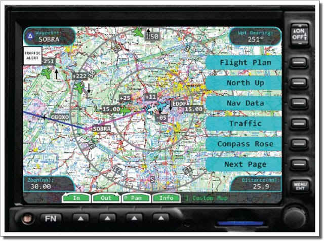
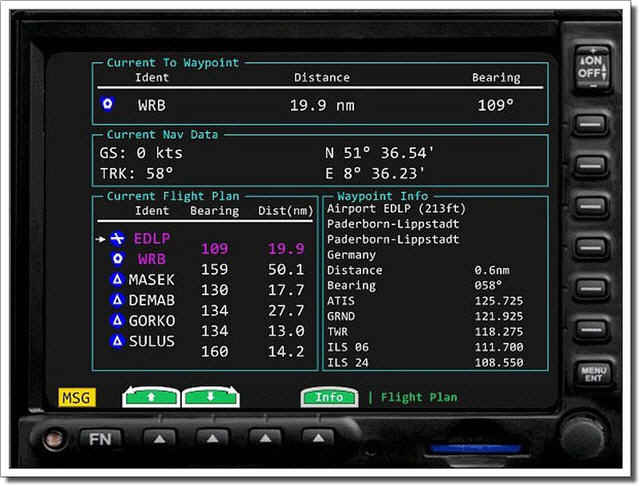
Moving Map - The Moving Map can access all the charts you have activated in the FSMap Windows application. Your own position will be shown on the charts and all relevant information (altitude, speed etc) will be shown as well. When a flight plan is loaded the route is shown and the bearing and distance to the next waypoint is given as well. With a single glance you will be able to see if your aircraft is in the correct location.
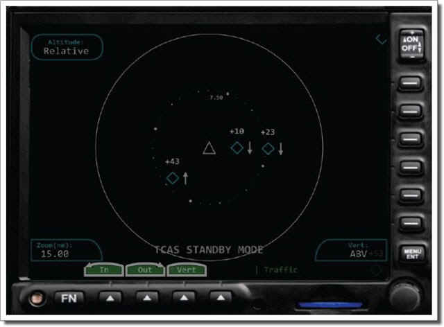
Traffic Collision Alert System - The Traffic Collision Alert System checks if there are aircraft too close to your aircraft and alerts you to their presence. When the other aircraft seems to be on a collision course the alert status will be increased and audio warnings will be heard.
SafeTaxi option - The SafeTaxi option overlays airport diagrams on top of the charts. When you zoom in you will see a detailed chart of the airport you are on. The data for these maps is taken directly from FS so you do not need to have special charts for this.
FEATURES
-
Fully licensed VFR charts for Austria, Belgium, Germany, Luxembourg, Netherlands, Switzerland included
-
Extensive map filtering for a type for maps (General, IFR, VFR, Airport) and then filter by IFR and VFR maps (General and Airport types are always) displayed.
-
Loads default FS flight plans and displays them on top of the charts
-
Every chart you got in bitmap format can be imported, from large scale enroute charts to the most detailed taxi charts (for example all USA sectionals and airport charts found on Avsim and other internet websites)
-
Can import maps from FSMovingMap
-
Options to export regions to share with others
-
Easy to add and calibrate charts so they can be used.
-
The gauge can be inserted into any panel using very easy interface (no editing of panel files needed)
-
The FSMap application connects to FSX using SimConnect, FS2004 and FS2002 connect via FSUIPC (registered version required).
-
The FSMap application can be run on a separate computer using SimConnect for FSX or WideFS for FS2004 and FS2002 (registered version WideFS required)
-
Highly professional development (like FS Flight Keeper)
Extra:
System requirements:
-
Microsoft Flight Simulator X (SP2) / 2004 / 2002
-
MS Windows Vista / XP SP2 / Windows 7
-
2 GHZ cpu multicore
-
1 GB internal Memory
-
256 MB Graphics card (DX9 compatible)
-
Unregistered FSUIPC needed for the FS2002/FS2004 version
-
Registered FSUIPC + WideFS version needed for FS2002/FS2004 when the software runs on a seperate computer (PAYWARE)
-
Download-Size: 226 MB
-
Installation-Size: 250 MB
|