|
PC Aviator Inc
::
DEALS & DISCOUNTS!
::
50% OFF ALL FSGENESIS TITLES
::
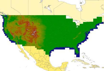
FSGenesis - United States Terrain Mesh FSX
|
FSGenesis - United States Terrain Mesh FSX
Search
Categories
- DEALS & DISCOUNTS!
- MS Flight Simulator 2020
- => NEW ADDITIONS
- => CLEARANCE ITEMS
- Flight Sim X Addons
- Prepar3D Addons
- FSX:Steam Addons
- X-Plane Addons
- Flight Sim 2004 Addons
- Other Flight Sim Addons
- MegaSceneryEarth
- Flight Simulators
- Air Traffic Control
- System Utility
- Flight Training Software
- PC Aviator Brand Titles
-
Boxed Software
- Flight Sim X Addons
- Flight Sim 2004 Addons
- Flight Simulators
- X-Plane Addons
- Prepar3D Addons
- Flight Training Software
- System Utility
- Flight Controls & Home Cockpit
- Books & Magazines
- Aviation Videos
OTHER
Your cart
Your account
Bestsellers
- FSGenesis - United States Terrain Mesh FSX
- FSGenesis - World Terrain Mesh FSX
- FSGenesis - Alaska-Hawaii Terrain Mesh FSX
- FSGenesis - NEXTMap Australia Bundle FSX/P3D
- FSGenesis - Canada Terrain Mesh FSX
- FSGenesis - NEXTMap Cuba Terrain Mesh
- FSGenesis - NEXTMap South Africa Terrain Mesh
- FSGenesis - NEXTMap Europe Bundle FSX/P3D
-->
Users online:
592
shopping
Powered by X-Cart php shopping cart
Copyright © 1999-2024 PC Aviator Inc